OC Transpo Overview
OC Transpo Route Maps
Google Route Adviser
OC Transpo Fees & Payment Methods
Rack & Roll
School Buses
Inter-City Buses
Inter-City Trains
Scroll down for information on the OC Transpo rapid bus and light rail system, school buses, and inter-city transport by bus and train.
Evaluation, News and Best Practices
Walkscore.com crunches open data to provide a transit rating for each neighbourhood in addition to scores for ease of walking and cycling to amenities. (Here’s a sample score for a postal code neighbourhood in Alta Vista; you can enter your own.) Mapnificent provides a comparable estimate, in this case using a location pin and a sliding time scale to estimate how far public transit can take you in a given amount of time. The unofficial Public Transit in Ottawa blog relays the latest transit news. Here’s a quick article with tips on how and why to use public transit, and here’s a recent study showing how Ottawa fares in relation to other New World cities. To learn about transit networks in general you can start with planner Jarrett Walker’s Human Transit blog and book, and with Taras Grescoe, author of Straphanger and compiler of this list of web resources. For active transportation (walking, cycling, &c) on Slow Ottawa go here.
OC Transpo
Overview
As indicated in the overview map below, there are three main components to the City of Ottawa’s Rapid Transit Network, namely:
- a core system of dedicated bus (Transpo) lanes (shown in green);
- a more extensive system of buses on shared streets (shown in black);
- a light rail (O-Train) line (shown in orange). An east-west line is under development.
Click on the map for the source image—an overview embedded in a far more detailed map of the entire network, including 14 park-and-ride lots (shown in light grey) providing free parking near high-frequency stations,

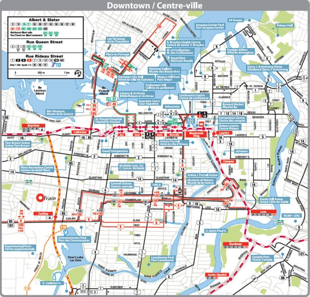
From the same source, here’s a map of the downtown portion of the rapid transit network. The original image can be seen in greater detail by clicking on the image and zooming in on the inset at lower right.

And here is the long-term vision for the Light rapid transit system. Click image for full schedule and large map via City of Ottawa.
Individual Route Maps
Click on the image below for all OC Transpo timetables, and printable route maps in the format shown.
Route Adviser on Google Maps
If you enter a route on Google maps and click on the train icon above the address, you will see the recommended route. Click on the image below for a sample route, and change addresses for a new search.
Fees & Payment Methods
You can pay for the city bus and O-Train with cash (most expensive), tickets or a Presto smart card (least expensive). For current adult, senior student and child rates go here. For Para Transpo—a service for registered riders who are unable to use conventional OC Transpo buses—go here.
The Presto smart card can be purchased at OC Transpo Sales and Information Centres, or you can order your card online by clicking on the image below. There’s a delay of two business days when adding money to your card online, so you’ll need to plan ahead. These cards also work on the Toronto and Hamilton transit systems.

The PRESTO card is a durable plastic smart card that serves as per-ride payment or a monthly pass. Click image to purchase or reload online.
Rack & Roll
From April through October many OC Transpo buses come equipped with bike racks on the front. and they can be transported year-round on the O-train. Click here for details, and here for an instructional video.
School Buses
For the school bus system visit the OSTA site.
Inter-City Buses
Buses from Ottawa to other cities are operated by Greyhound.ca. Click here to book.
Inter-City Trains
Inter-city trains along the route below are operated by Via Rail. Click here for the Ottawa station page and booking information.


